Events in 2008 and 2009
September 2009: You think it has been cold this fall? September second warmest ever!
There have been plenty of complaints about the chill in the air over the past couple of weeks, and reports of double-digit cold in the Prairies, with snow and ice. We could easily be led to think that global warming has ended, at least temporarily, and maybe that the Ice Age is returning. However, take a look at Jeff Masters' Wunderground.com website entry for 16 October - it turns out that September 2009 is the second warmest ever, and of all places, the Canadian Plains were the warmest! Not only was it warm on land, but at sea too - with the Arctic ice pack down to the third-lowest on record, and open water through both the Northwest and Northeast Passages. With a modest El Niño building, stay tuned for more records to fall all winter.
16 September 2009
The End of the Hadean has just been pushed back 250 m.y.
In an article in Science released on 26 September, a new claim has been laid for the oldest rocks in the world. For many years this claim has resided in the North American craton, first in Labrador, then west Greenland, and for the past 20 years or so in the Acasta Gneiss from the Slave Province. The article reports an age of 4.28 Ga for rocks from the Nuvvuagittuq greenstone belt in the Superior Province. Preliminary reports and TV shots on the Discovery Channel indicate the rock analyzed is a very garnet-rich gneiss, although CBC refers to them as "faux-amphibolite" - presumably a hornblende-bearing rock, derived from the metamorphism of mafic volcanic rocks.
25 September 2008
Launch of the Geological Map of the World
For the first time, geological surveys from 79 countries are participating to produce a comprehensive online geological map of the entire planet. Through www.OneGeology.org, the new digital geological map of the world will do for geology what Googlemaps did for geography. The new map will be launched at the International Geological Congress in Oslo in August, but is already available on the website.
1 August 2008
Joggins fossil cliffs declared a UNESCO World Heritage Site
The Joggins Fossil Cliffs along the shore of Cobequid Bay, recognized as the site where the earliest scientific evidence of reproductive life on land was discovered in the mid-19th century, were declared as Canada's 15th UNESCO World Heritage Site. Dubbed the "Coal Age Galapagos" for their rich deposits of fossils from layers of ancient ecosystems, the gently dipping rock layers are eroded daily by the Fundy tides, exposing evidence of ancient vegetation
and life.
The site was referenced by Charles Darwin in The Origin of Species, after he heard about it from Charles Lyell, the pre-eminent geologist of the mid-1800s. Lyell and fellow geologist William Dawson discovered a fossilized reptile embedded in the cliffs. The stratified layer the ancient reptile was found in showed evidence of life on land that predated previous discoveries of reproductive life. What struck geologists from the mid-19th century were the trees - some towering as high as seven metres - entombed in sandstone in the cliffs.
Joggins joins other notable Canadian geolandmarks like Dinosaur Provincial Park, the national parks of the Rockies, and Gros Morne National Park as a World Heritage Site.
8 July 2008
Chinese M7.9 earthquake, 12 May
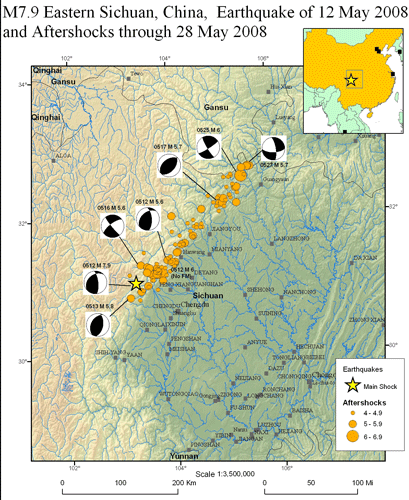
A very strong M7.9 earthquake occurred in Sichuan Province, SW China in the afternoon of 12 May 2008, followed by many aftershocks, several with magnitude in excess of M6. The earthquakes occurred in a 200 km long zone along the western margin of the Sichuan Basin, where the extruding Tibetan Plateau has encountered the older crust of the Sichuan Basin. Although no obvious fault exists at the surface, the earthquakes happened at a depth of 10-30 km, and occurred along a buried fault system, a splay of the Longmenshan Fault. The map below shows the location of the epicentres of the main event and the aftershocks, and the first motion studies demonstrate that both thrust fault and transcurrent fault motions occurred. This area is region of enormous relative relief, with altitude rising from 500 m at Chengdu to 5000 m in the mountain ranges to the west. The mountains are deeply incised by rivers, resulting in extreme relief - a sure recipe for many landslides.

[Map from USGS - see their page about this earthquake.]
The winter of 2007-08: pretty average in Nova Scotia
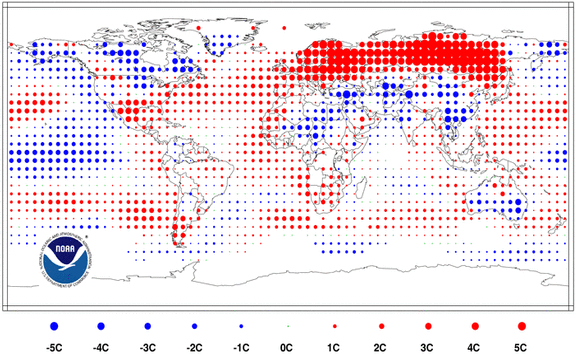
Although the winter just ended was warmer globally, here in Nova Scotia it turned out to be close to average for temperature. Major warm temperature anomalies were experienced across Russia, Scandinavia and Europe, bringing those daffodils along in Britain 2 weeks early. Central and Southern Asia, however, endured cold weather, with snow in Baghdad and extreme conditions in Afghanistan. Overall this winter was the 16th warmest in the 123-year global record.
From National Climatic Data Center - click on map for larger version
The global winter temperatures this year result from a tug-o-war between the forces of global warming (it was in the warmest 15% of all winters on record) and the on-going strong La Niña event, which has caused significant cooling in the central Pacific.
Precipitation globally was higher than average in eastern North America, northwestern Europe and parts of Australia and South America, resulting in deep snows in Ontario to New Brunswick, and major flooding in Queensland and Bolivia. Dry conditions occurred in southern Europe and western North America. While meteorologically winter ended on 1 March and astronomically it ended on 20 March, residents of much of eastern Canada await the spring melt with some trepidation, expecting significant spring flooding this year. Nova Scotians benefited from having the track of several winter storms go north of them, resulting in frequent rain events which kept our snowpack to a minimal level.
For more details, see the National Climatic Data Center webpage.
23 March 2008
2007: How hot was it??
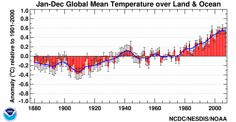
According to the US National Climatic Data Center, the year 2007 ended as the 5th warmest year on record, worldwide. For the land masses, it ranked as the hottest year on record, but the persistent El Niño in the second half of the year helped lower the ocean temperatures such that it was the 9th warmest year on record at sea. Records extend back to 1880. The warm trend of the past two decades is still very pronounced, with 7 of the 8 warmest years occurring since 2001 (the 8th one was 1998).

[Click on graph for full-size version.] Image from National Climatic Data Center.
BC Earthquakes
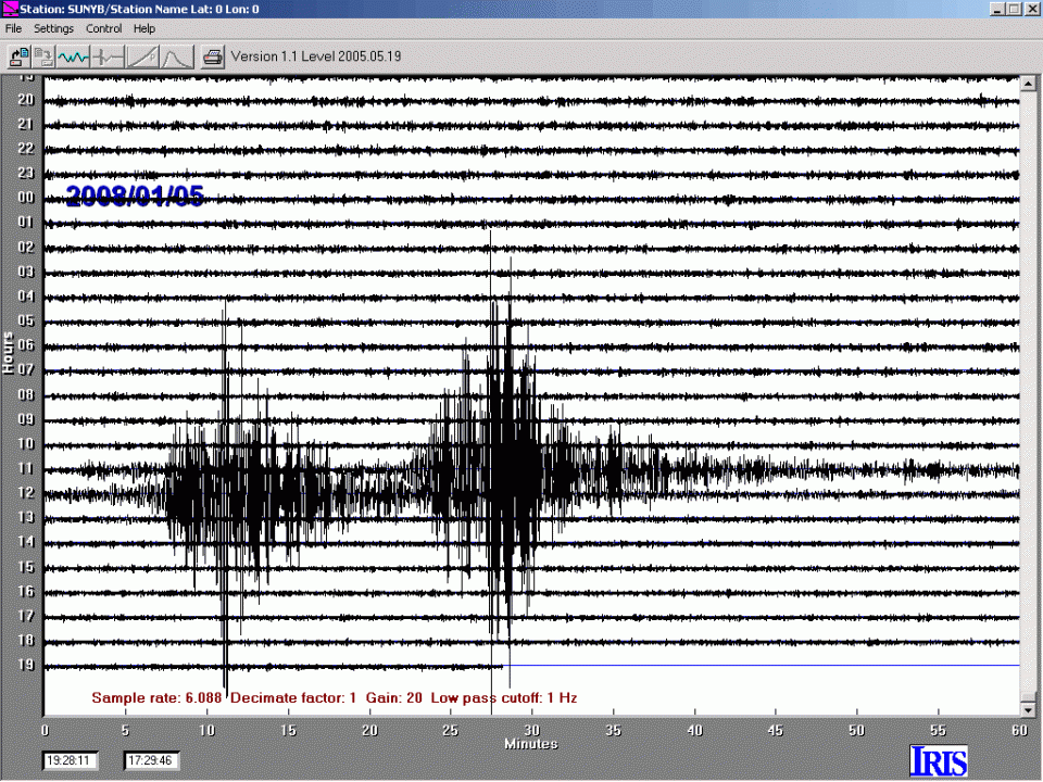
Early in the morning of 5 January, local time, three substantial earthquakes rattled the southern tip of the Queen Charlotte Islands. At magnitude 5.0, the first tremor was significant, but it was followed about 10 minutes later by a 6.7 jolt, and then be a series of aftershocks, the largest of which came about 40 minutes later, at 5.6. All three events were picked up by the Acadia seismograph, although the first one is rather lost in the second event.

[Click on graph for larger version.]
The main event was the largest earthquake in Canada since 2004, when an other earthquake occurred in the same West Coast region, where three tectonic plates meet - the Pacific and Juan de Fuca plate are actively spreading, but the spreading ridge is being subducted under the North American plate. Currently the portion of the spreading ridge that is being subducted is a transform fault offset, and it appears from first motion studies of the 2008 event that it was caused by movement on this small transform step.
For previously listed events, please go to the Recent Events archive for 2006 and 2007.
