Geology and Flora of the Agriculture Canada Research Station Natural Park, Kentville
By J.A. Colwell & S.A. Ferguson and S.P. Vander Kloet
 ROUTE - From Wolfville go west on Highway 1 (Main
Street,
Wolfville) for 7 kilometres. Parking is at the junction of Highway 1 and
the
entrance to the Research Station. A trail from the parking area leads
upstream
to the portion of Elderkin Brook between Highway 1 and Highway 101.
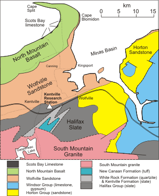
DESCRIPTION - Outcrops of Triassic Wolfville Formation occur at intervals along the valley for a distance of about 800 metres. This part of the Wolfville Formation consists of a poorly cemented brick red to reddish brown sandstone. At the junction of the tributary brook the rock contains a few angular to subrounded pebbles up to 6 centimetres in diameter. Poorly defined bedding dips gently north. No fossils are known to be present here. Thin section work shows that the rock consists of angular quartz grains cemented with variable amounts of hematite, calcite and minor limonite. Small light green patches are due to the presence of chlorite.
The bedrock of the upper part of the valley that can be reached by the trail is Halifax Group of Ordovician age which unconformably underlies the Wolfville Formation. The contact is not exposed here. These rocks are slate and minor siltstone having alternating bands of lighter and darker grey colour, with some beds of a greenish shade. The slates are finely banded, individual beds ranging from millimetre scale laminae up to beds a few centimetres thick. The bedding strikes northeast and dips about 60 degrees southward and axial planar cleavage is almost parallel to bedding. Graptolites have been found in these rocks in the area but none have been reported here.
The upper part of the valley is a steep-sided ravine whereas the lower part is more open, with a sandy alluvial plain on the valley floor. The area has one of the mildest climates in the province, and because of the favourable soils and climates is in forestry class 4. The trees are old growth with little evidence of cutting. These features contribute to the large height and girth of the trees and variety of plant life.
Large old-growth hemlock and red spruce grow on the valley slopes. The floodplain forest includes hemlock, sugar maple, white pine, red pine, red spruce and american elm. The flora is well developed, with 125 species of flowering plants and 20 species of lower plants recorded. Species which are local or otherwise distinctive includes the orchids Corallorhiza tifidia, C. maculata and Cypripedium acaule; parasitic beech drops Epifagus virginiana; Jack-in-the-Pulpit Arisaema stewardsonii, the lesser scouring rush Equisetum sciripoides. The common ferns are: Ostrichfern (Matteuccia struthiopteris), Osmunda cinnamonea,. Onoclea sensibilis, Thelepteris palustris, Dryopteris phegopteris, D. spinusola, D . marginalis, Polystichum acrostichoides and Polypodium virginianum.
Prepared for the Geological Association of Canada and Mineralogical Association of Canada Joint Annual Meeting in Wolfville, Nova Scotia, May 25-27, 1992. Meeting Hosted by the Atlantic Geoscience Society.
