|
|
|
|
|
|
|
|
|
|
|
|
Objective 1: Baseline Grid |
|
|
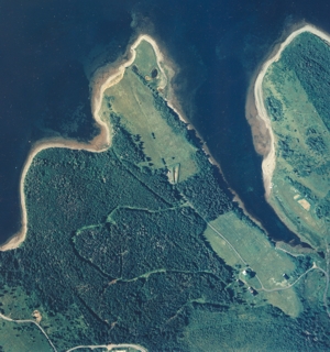
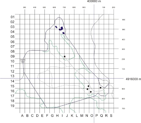
In order to organize a sampling plan and maintain consistency over time, a baseline grid was developed for the property. The grid was divided into 50 metre by 50 metre sections and referenced to NAD83 UTM map data. Intersection points were recorded and flagged in the forested areas using orange flagging tape. Position was estimated using GARMIN-12 GPS units. Figures 2 and 3 show a 1992 aerial photograph of the Morton Centre property alongside the baseline grid: |
|
|
|
 |
|
Figure 2: 1992 Aerial Photograph of the Morton Centre Property |
Figure 3: Baseline grid composed of 50 m by 50 m cells |
|
Objective 2: Overview of Biodiversity, Ecosystem Structures and Geological Elements |
|
|
It is important to not that in the 4 month period, it was impossible to catalogue all elements. With guidance from Dr. Ed Reekie (Biology Department, Acadia University) it was decided that it would be wise to begin a species list, focusing on terrestrial flora. Rigorous sampling was conducted, concentrating on terrestrial flora (see SEA: Methodology) although any sightings of faunal species (birds, reptiles, amphibians and mammals) were recorded. |
|
|
As the summer progressed, the complexity of the species list grew. Digital photographs were taken with a 4.3 megapixel camera in .tiff format of plants in situ. In addition, samples of flora were dried and scanned at 300 dpi for archival purposes. |
|
|
It should be noted that ecosystem structures and geological elements were addressed in the Strategic Environmental Assessment (Objective 7). |
|
|
Objective 3: Factors Having Impact on the Property |
|
|
Factors and influences having an affect on the property were addressed in the Strategic Environmental Assessment (Objective 7). |
|
|
Objective 4: Systematic Methods of Sampling |
|
|
In order to gain a comprehensive picture of the terrestrial flora (excluding coastal plain flora) it was decided that forest diversity plots and transects of the agricultural areas would yield the best results. These methods and results are found in the Strategic Environmental Assessment. |
|
|
Objective 5: Database Reflecting Grid Structure |
|
|
This database began as an excel spreadsheet cataloguing the name, GPS location and time of sampling for each plant species found. Later this information, with the addition of digital, was compiled to form a digital herbarium. This herbarium is contained on this site as a resource. Original, high quality digital images can be obtained from the Environmental Science Program at Acadia University. |
|
|
Objective 6: Network With Other Research Groups / Community Groups |
|
|
Not completed by the project team. |
|
|
Objective 7: Business Plan and Strategic Environmental Assessment |
|
|
The Strategic Environmental Assessment was carried out by the team leader as an Honours Project, and incorporated data collected for the Preliminary Resource Inventory. The business plan was not completed by the project team. |
|
|
Objective 8: Final Report and Display Materials |
|
|
The final report was not completed by the project team. Display materials were developed in the form of posters and this website, however, to promote the project and provide resources for future projects at the Morton Centre. |
|
|
|
|