Geology and Scenery of the White Rock Area
By J.A. Colwell & S.A. Ferguson
 LOCATION - White Rock, southwest of Wolfville in
the
Gaspereau Valley.
ROUTE - Go south on Gaspereau Avenue toward Gaspereau, turning right onto the White Rock road. Continue west to the intersection in White Rock. Turn south and go downhill to the bridge, parking on the left just after crossing the bridge. A footpath leads along the south side of the Gaspereau River to the Hellsgate powerhouse, the lowermost of three hydro power stations on the Black River.
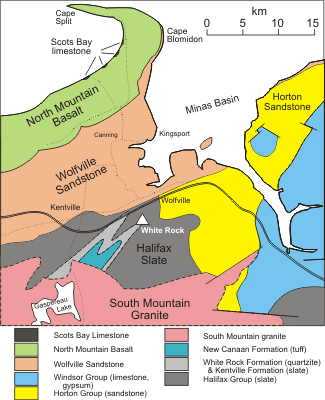
DESCRIPTION - There is a scenic view along White Rock Pond from the parking area. A small outcrop of Silurian (about 420 million years) Kentville slate lies at the south side of the parking area . Along the path are large exposures of White Rock quartzite, with occasional small quartz veins. Bedding is not apparent in the quartzite, but there is a small outcrop of slate with nearly vertical bedding just west of the footbridge over the Black River. A second, older quartzite unit can be seen at and south of the footbridge. There is a larger outcrop of the second unit on the east side of the Black River near the power station, followed upriver by Halifax slate.
The White Rock quartzite is more resistant to erosion than other rock types and exposures are common in the vicinity. It is commonly used in buildings in the area, including several on the Acadia University campus (War Memorial Gymnasium, Horton House), although blocks are very irregular in shape. The fresh rock is gray in colour, but most surfaces exhibit the reddish hematitic (iron oxide) stain that coats fractures. Several small quarries may be found north, east and west of White Rock .
White vein quartz, often used with the quartzite, as in the wall around the old graveyard in Wolfville, was obtained here as well (sites now largely overgrown).
The erosion resistance of the quartzite has led to the capture of the Black River by the Gaspereau River. As will be apparent from the map, if you were to return to the parking area and drive north through White Rock, continuing north on the winding Deep Hollow Road, you would be following the former route of the Black River. The resistance of quartzite and slate north of White Rock allowed the Gaspereau River, eroding its way from the east, to provide a lower outlet and thus capture the Black River.
Return to Wolfville by tracing the old route of the Black River northward. The large quartzite outcrop just north of White Rock was an obvious impediment to the River. The former Horton District High School, at the intersection with Highway 1, is built on the former delta of the Black River. Turn right and follow Highway 1 to Wolfville.
John A. Colwell and Stewart A. Ferguson, Department of Geology, Acadia University, Wolfville, Nova Scotia 1992
Prepared for the Geological Association of Canada and Mineralogical Association of Canada Joint Annual Meeting in Wolfville, Nova Scotia. May 25-27, 1992; meeting hosted by the Atlantic Geoscience Society.
